
Oaks ‘n’ Folks – Volume 20, Issue 1 – January 2004
Hardwood rangelands cover 10% of California, and are composed of an overstory of various hardwood species, predominantly oaks (Quercus spp.), and an understory mainly composed of introduced annuals (Gong et al., 2000).
Tree crown closure (also referred to as crown cover, canopy cover, and canopy closure) is defined as the percent of forest area occupied by the vertical projection of tree crowns. It is commonly used as a measure of stand density and an indicator of wildlife habitat.
Aerial photo interpretation techniques have been used in classifying hardwood types and tree crown closure estimation. However, they are dependent on the experience of photo interpreters.
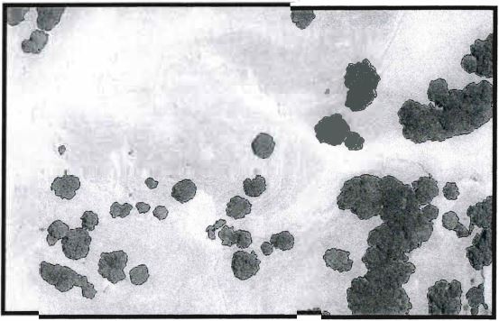
In recent years, we have developed digital image analysis techniques to extract information about hardwood rangelands. Black and white aerial photographs can be scanned at a ground resolution as fine as one foot. Scanned digital aerial photographs can be orthorectified to remove the perspective effects and change of scale caused by surface relief (Figure 1). Such data can then be analyzed to extract crown closure (Figure 2). Finally, digital surface models (DSM) can be built to allow change analysis in 3D; i.e., growFigure 2. This zoomed in image shows crown closure extracted from the orthorectified image.th in the vertical direction can be obtained (Figure 3).

| Reference |
| Gong, P., G. Biging, and R. Standiford, 2000. The potential of digital surface model for hardwood rangeland monitoring. Journal of Range Management53:622-626. |
Peng Gong
Professor, Department of Environmental Science, Policy, and Management, University of California, Berkeley